Sunday, June 25, 2006
Geoportail - impressions of the homepage
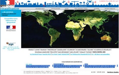
France's new mapping service at GeoPortail continues to be suffering from huge demand, and hence to be generally unavailable. I did however once succeed in getting up the home page, a screenshot of which is shown here, and there's enough to be seen there to allow for some comments.


- The site is all in French! OK, so thats the political reality of this being set up by French government dictact, but if the objective is to encourage interest in France and French culture, then making it more accessible to those outside the country, speaking different languages, would seem to be a valuable feature. (The site is also (un)available at geoportail.com, but this just redirects to geoportail.fr)
- There are 3 stages outlined
- Summer 2006 (now) - aerial images and scanned maps
- Autumn 2006 - 3D viewer, and initial data sets
- 2007 - a rich set of public information available, plus WebServices
- The page is hardcoded for a screen size of 1024x768 - if you have a smaller screen then there's a lot of scrolling needed, and a larger one wont give anymore useful info. This is not the way to handle such graphically rich applications as mapping - they really do need to use all available screen space to show as large a map as possible. The layout is achieved via tables, rather than via CSS.
- Coverage entends to
- FRANCE
- CORSE
- REUNION
- MARTINIQUE
- GUADELOUPE
- ST MARTIN
- ST BARTHELEMY
- GUYANE
- ST PIERRE ET MIQUELON
- NOUVELLE CALEDONIE
- MAYOTTE
- ILES KERGUELEN
- ILES CROZET
- WALLIS
- FUTUNA
- The initial map shows the whole globe - with no zooming or other controls on it. If you move the mouse over the map, certain hidden areas are clickable - merely indicated by the mouse pointer changing to a hand pointer. (These areas are of course those listed above).
- There's a built in feature for bookmarking favourite locations. The current top 3 are
- Le Terminal Trans-Manche (62)
- Le Mont-Saint-Michel (50)
- Le Château de Chambord (41)
- The geoportail site is for the "visualisation"; there is a separate site for the "geocatalogue" (and this site, since it has nothing but a holding page until Sept 2006, is available). The visualisation does not include any search box, to direct the map to a particular location.
- In a commendable effort to be openly available to as many users as possible, the site is
- Much of the site is using php to serve up the pages, even for what would appear to be static information - perhaps that's part of the problem as to why the servers cant cope with the demand.
compatible with IE6 and greater, Mozilla 1.7 and greater, Firefox 1.0 and greater, Safari 2.0 and greater, and OSs Windows 2000, XP, Linux (Redhat, Suse, Debian), Mac OS X